The Heart of Snowdonia
I took the opportunity of good weather and light winds to get a decent training session ready for the upcoming Swiss Irontrail in August. To get some strength into my legs I decided to use a route based on the Paddy Buckley Round(PBR) and the Heart of Snowdonia Challenge Walk (HSCW) in North Wales.
The T121 is a 128.1km route with 6990m +/- starting and finishing in Davos, Switzerland (http://www.irontrail.ch/en/trails/t121/). My training goal for ultra-distance events is to comfortably complete 40%, this improves strength and stamina without creating too much tissue damage and has worked for both Ironman Triathlon and the Marathon des Sables.
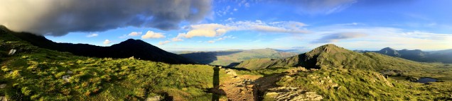
I started out at 10:30 on a warm but overcast morning outside the café in Capel Curig heading south past the Pla y Brennin Outward Bound Centre. Leaving the shrieks and squeals of kids learning to kayak behind, I ascended the path to Moel Siabod heading South. Once on top the weather cleared up and the sun came out giving some great views of the National Park. I avoided the descent down the back of Moel Siabod as per the HSCW since my map did not cover the area and followed the PBR along the ridge line to Cnicht. The route roughly follows an boundary fence and is very boggy. Once at Cnicht I reverted to the HSCW, the descent is quite steep and the rocky which is not helped by the rock strata being inconveniently angled. A note for the future would be to continue south about a kilometer and pick up the foot path to the lake. Once off the steep slope the descent to Geli Lago is quite beautiful and at this time of year the valley is an incredibly lush green. There are signs out informing the walker that they are building a micro-hydro to generate electricity of the local population which sounds quite innovative until you walk past the ruined farm and water-wheel.

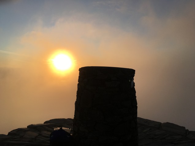
Crossing the road to Beddgelert the route ascends the Watkins path along the Afon Cwm Llan and veers left at the mine workings to take the ridge to Crib Tregalan. Evening was closing in now and though there were good views all around Snowdon summit was shrouded in cloud. I arrived at the summit just before sunset and got a couple of nice images as the clouds cleared. There were a few people getting ready to sleep on the summit so I had a terrible freeze dried meal and continued my walk to test out a new head torch.
I quite like walking at night, it changes all the normal references but I decided to stop and bivi until dawn on top of Moel Cynghorion.There was a little light drizzle during the night but dawn was clear again as I descended the track to LLanberis past quite a few abandoned sheep farms and mine tailings.

The view is dominated by the huge slate Dinorwic mine (1787-1969) above Llanberis going almost to the top of Elidir Fach.
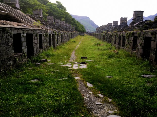
Llanberis is now quite a sleepy little town with lots of small camp sites and B+B’s but looking at the size of the old churches and Chapels reminds one that at its peak 3000 men worked in the quarry. The route leads up through the abandoned slate mine and is quite a sobering place when you think about the human labour involved getting the slate out of the mountain-side. Eventually the track changes from mine to open hill side disappears. Ascending Elidir Fach and Fawr is quite hard as there is no obvious path on the Llanberis side until one has crossed the dragons back of loose boulders and can see Y Garn.
The last section is quite straight forward heading to the summit of Y Garn and then taking the west ridge down to Llyn Ogwen. The modern world returns as the small lake was teaming with visitors and school parties.
Total distance covered was 55km in 16 hrs.40min and total ascent 3881m. Perfect.
